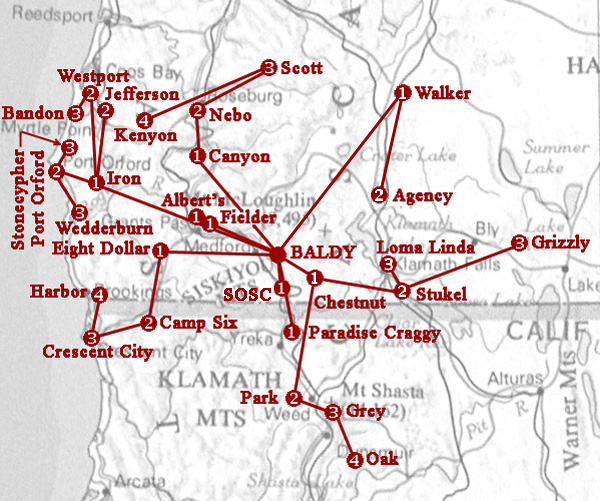
Network Map
Translator Sites and Signal Paths
Disseminating the Signal
KSOR's studios were located on the campus of Southern Oregon State College (SOSC), now named Southern Oregon University (SOU). A microwave studio-transmitter link (STL) conveyed programs to Mt. Baldy (BALDY on the map). The 2,000-watt transmitter broadcast to the residents of the Medford-Ashland area. Low-power translators were strategically located to relay the signal to communities that were beyond the reach of the transmitter on Mt. Baldy.
Design Criteria
The rules of the Federal Communications Commission (FCC) had priority over other concerns. Each translator was required to deliver a signal to one or more established communities. Although a translator had the capability of providing a signal for yet another translator, thus further extending the broadcast coverage, it could not be used for that purpose alone.
With minor exceptions, radio signals for FM broadcast travel in a straight line. For this reason, the features of mountainous terrain played a large role in the selection of a translator site. It was essential that the radio site from which the signal was arriving be clearly in view, and the area being served be free of any obstruction to the radio waves.
On the map above, each translator site has a number that represents its position relative to the transmitter on Mt. Baldy. When relaying KSOR's signal, each translator added a small amount of noise and contributed its own risk of service interruption due to equipment failure or loss of electric power. Units at the Kenyon, Oak and Harbor sites, being the last in a line of four translators, had the greatest vulnerability to distortion, noise and interruption of the signal.
Translator Groups
Three groups operated as a chain, with each translator in succession rebroadcasting the previous source. Two groups operated as a tree, branching out to multiple areas from a single translator.
The translators at Fielder Mountain (and Albert's Peak after it replaced Fielder), Central Hall at SOSC, and Paradise Craggy served distinct communities, but did not provide signals for other translators.
Solar Power
Six translator sites were powered by solar energy: Iron Mountain, Fielder Mountain (but not Albert's Peak), Grizzly Peak, Paradise Craggy, Park Mountain and Camp Six.
Changes
Only minor aspects of the network were altered before 1987. After relocating the main transmitter to King Mountain, translators were added to the network, and groups were reconfigured due to the greater reach of the primary signal from its new location.
Accuracy
The map depicts only the relative positions of translator sites. For accuracy, refer to the geographic coordinates and topographic map given for each translator.
Credits
The underlying map is a selected portion of the "The National Atlas of the United States of America (1970), U.S. General Reference," courtesy of the University of Texas at Austin, the Perry-Castańeda Library Map Collection on the Web:
http://www.lib.utexas.edu/maps/national_atlas_1970.html#general_reference.html,
September 28, 2008