Eight Dollar Mountain
Serving Cave Junction, Kerby and Selma at 91.9 MHz
Location: seven miles north of Cave Junction (geographic coordinates and map).
Pictures were taken in March 2008.
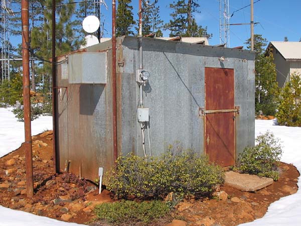
The Historic KBES-TV Building
This building originated with KBES-TV, Medford's first television station. This was the only structure on the summit when KSOR first installed its translator. It is now more than 50 years old.
This building served as a microwave relay station from about 1956 to 1963. It was one component of a link between KBES-TV in Medford and KIEM-TV in Eureka. The 2 GHz microwave linked the KBES transmitter on Blackwell Hill, three miles east of Gold Hill, with the KIEM transmitter on Kneeland Mountain, twelve miles southeast of Eureka. The relay at Eight Dollar Mountain and a relay at Baldy Mountain, two miles southeast of Grants Pass, completed the link. (Bill Kirk, telephone conversation, March 14, 2008)
Bill Kirk was KOBI-TV's chief engineer at the time we installed the translator. Bill started with KBES-TV in 1956, continued as the call letters changed to KTVM and then KOBI, and retired in 2006. Although semi-retired since 1996, his affiliation with the TV station spanned a period of 50 years.
The First Translator
A Tepco J-317 translator was housed in a steel box mounted on a mast that also held the two transmitting antennas. A power divider provided nine watts to the antenna serving Cave Junction and one watt to the antenna serving Selma. The mast was a two-inch pipe set in a hole that young, energetic volunteers had dug by hand. A similar mast was set 100 yards to the north for the receiving antenna. Aluminum semi-rigid coaxial cable was left on the top of the ground between the translator and the receiving antenna.
The poor reliability of the translator was a serious problem. When the weather changed, the translator would either go off the air or transmit spurious signals that interfered with television translators or the Cable TV receiving facility. We needed a dependable translator.
The Second Translator
A Television Technology XL10-FM2 translator made a significant contribution to signal reliability. New antenna towers were installed using components of the modular tower system, and the translator was placed underground in a ferrocement vault at the base of the transmitting antennas. The dual-output translator provided 10 watts to each antenna. The FCC Search Details record this upgrade being licensed on July 19, 1983.
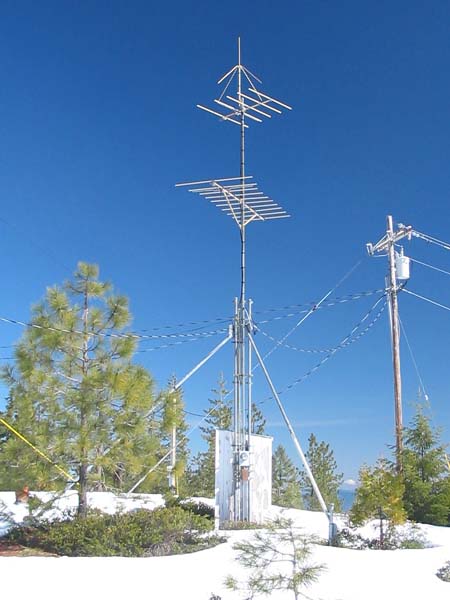
Transmitting Antennas
In the picture above, the two horizontal antennas were used with both the J-317 and XL10-FM2 translators. The upper antenna, a Scala HDCA-5, served Kerby and Cave Junction, and the lower antenna, an HDCA-10, served Selma.
The ground-plane antenna on top of the tower was later installed to facilitate broadcasting a second program service with a second translator. To provide additional space, an equipment shelter was set above ground using the original vault as a foundation. JPR Rhythm and News is now (in the year 2008) broadcasting at 90.9 MHz with 78 watts of effective radiated power (ERP), horizontally polarized, from the original yagi antennas. The ground-plane antenna is broadcasting JPR Classics and News on 89.5 MHz with 83 watts ERP, vertically polarized. The FCC Database records the authorizations for JPR's Classics & News on 89.5 MHz and JPR's Rhythm & News on 90.9 MHz.
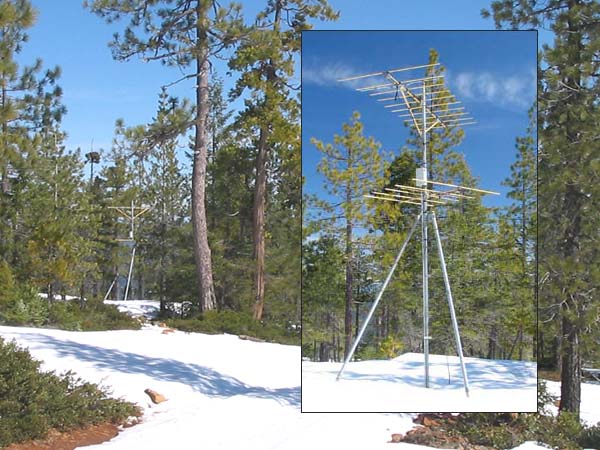
The Receiving Antenna
The antenna for KSOR's second translator was the ten-element yagi at the top of the mast. The lower antenna is a recent addition. The small metal box housed the preamplifier that overcame the signal loss in the long length of coaxial cable. One-half inch steel conduit was buried from 18 to 24 inches for the entire distance from the translator vault to the receiving antenna mast.
When planning this installation, we used 15-minute topographic quadrangle maps to evaluate the signal path from Mt. Baldy. It was found that a line-of-sight path did not exist. At the time, we did not have the mathematical tools to evaluate the effect of diffraction on signal strength, so we conducted an aerial survey.
Aerial Survey
The station chartered a Cessna 172 from the Ashland Airport.
The author, John Patton, had previously been an FAA Certified Avionics Technician, so he was well acquainted at the airport. The Fixed Base Operator (FBO) granted permission for him to install a temporary antenna on the airplane for receiving KSOR's signal from Mt. Baldy.
With the pilot flying a large circle, he started by measuring the signal strength at mountaintops near Roseburg, then surveyed prominent peaks over a long section of the Coast Range, and finally, took a close look at Eight Dollar Mountain. The data provided the basis for early decisions in the design of the translator network.
At Eight Dollar Mountain, the pilot flew a tight circle around the summit. At the proposed translator site, the signal from Mt. Baldy was weak. More important, it diminished to the south, but increased markedly to the north. This established the rationale for placing the receiving antenna north of the translator.
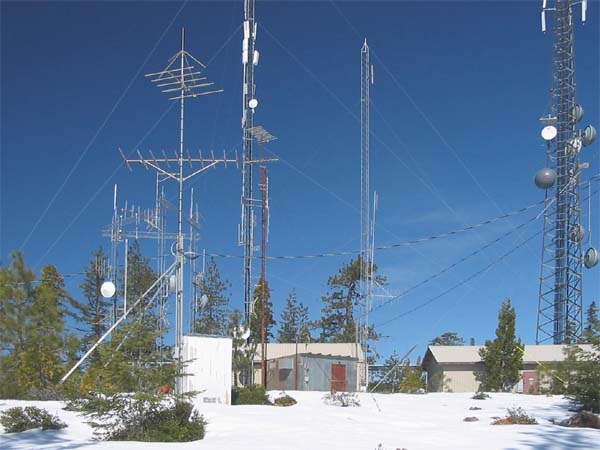
A Forest of Antennas
New radio facilities overshadow the historic KBES-TV building and the KSOR translator. An additional building and tower are beyond the left edge of the picture, and behind the photographer, there is still another building and tower that accommodate two full-power FM broadcast transmitters.
Documents from the FCC Database
(http://www.fcc.gov/fcc-bin/fmq?list=0&facid=62996)
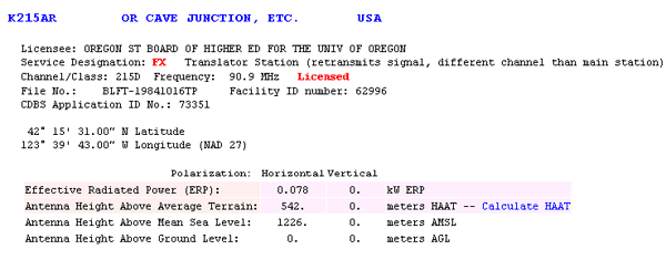
FCC's 2008 Authorization for JPR's Rhythm & News on 90.9 MHz
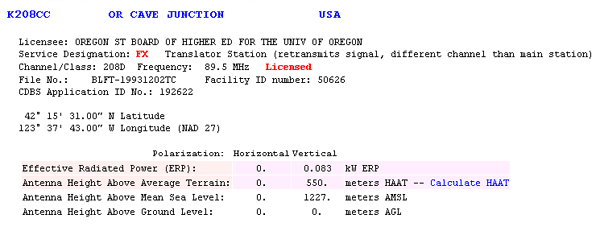
FCC's 2008 Authorization for JPR's Classics & News on 89.5 MHz
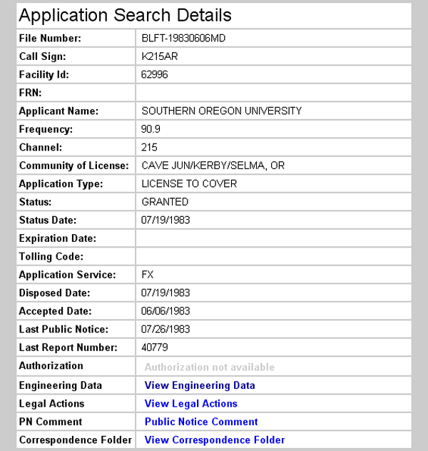
License Grant for new XL10-FM2 in 1983
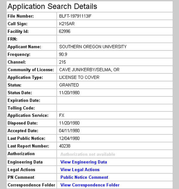
Initial License Grant 1980
Topographic Map
Eight Dollar Mountain Quadrangle, U. S. Geological Survey
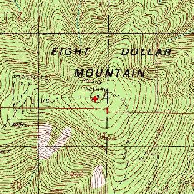
CONTOUR INTERVAL 40 FEET
Geographic Coordinates from the GPS: 42° 15' 31"N, 123° 39' 43"W (NAD27)
Antenna Height Above Mean Sea Level: 1,228 meters (4,028 feet)
The black dot identified on the map as a radio facility is the historic KBES-TV building.