Grey Butte
Serving Mount Shasta City and McCloud at 88.3 MHz
Location: The geographic coordinates recorded in the FCC Database are those of the Grey Butte summit. The KSOR translator was installed 1,600 feet southwest of this point, four miles south of the Mount Shasta summit and eight miles east of Mount Shasta City (geographic coordinates and map).
Pictures: 1997 and 2008.
Grey or Gray?
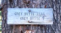 Both spellings are in common usage. The trailhead sign at the left is located near the Panther Meadow Campground, while the sign at the lower right is less than one-half mile away (August 2008). "Grey" appears in the websites for the USDA Forest Service and Mount Shasta Chamber of Commerce, but many maps and hiking guides use "Gray."
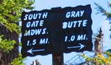 Articles in the Mount Shasta Herald referred to "Grey" Butte as early as 1927 and to "Gray" Butte in 1931. The Forest Service has not adopted a standard spelling. (Based on information provided by Julie Cassidy, Archaeologist / Heritage Resources, USDA Forest Service, Mount Shasta City, August 22, 2008)
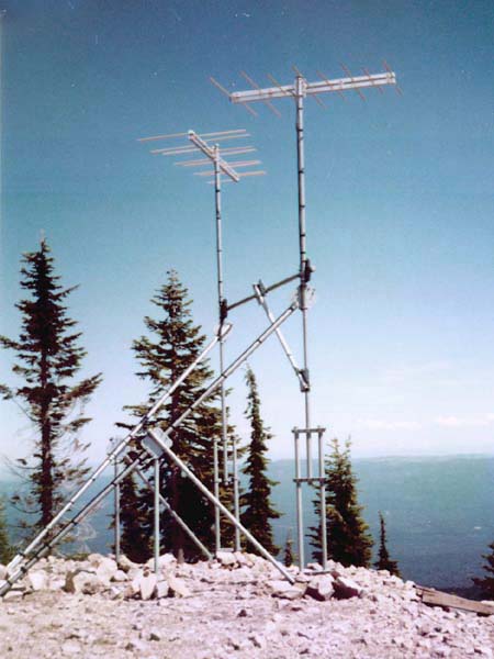
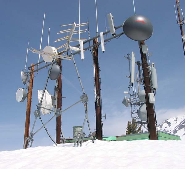
Transmitting Antennas – 1997
One transmitting antenna is directed to Mount Shasta City, and one to McCloud. Originally, the diagonal braces spanned the entire distance between the vertical towers and the ground, but proved inadequate for winter conditions.
If you look at the picture of the Gray Butte diagonal braces, that is what they looked like after I repaired them. After the diagonals you installed got bent nearly to the ground, they had pulled the antennas back until they pointed nearly vertically. You will see that I added two more diagonal braces as well as vertical supports from the ground. When I finished that two-day project, I foolishly dared the powers that be to damage that repair. I have not seen it, but I have heard the pipe just bent on either side of the vertical brace. . . so much for my dare. Nature bats last and always wins! The near glacial forces of 30+ feet of snow are amazing. If I had it to do over again I would have installed 20' lengths of heat tape under each of the two 2" diagonal braces. A tiny bit of heat is all it takes to prevent this. Live and learn. (Todd Cory, email with picture, February 12, 2008)
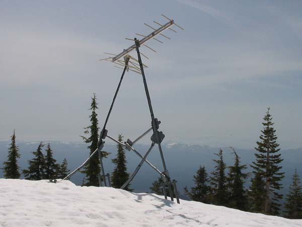
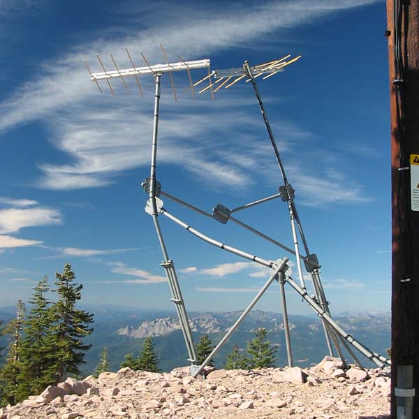
Transmitting Antennas – May 2008
Eleven years later, the masts are bent, and the antennas are severely damaged.
The Scala CL-FM log-periodic antennas are mechanically strong and quite forgiving in their use of radiofrequency power. Even bent and broken, these antennas continue to broadcast a listenable signal to McCloud and portions of Mount Shasta City.
Wow. . . those colorlogs are WAY more messed up than the last time I worked on the mounting structure. Now the antennas are damaged as well. I am surprised they still propagate any signal at all. The only thing that works well up there are poles. ANYTHING diagonal (even guy wires) will get crushed by the weight of the snow. (Todd Cory, email, May 11, 2008)
In the picture just below, each of the four wood poles originally had a heavy steel cable supporting it from both the north and south side. All of the cables have been either broken or removed. It appears that the vertical poles can survive, but not diagonal braces or guy lines of any kind.
The Power of Winter Storms
Storm winds coming from the northwest accelerate as they pass Mount Shasta. It is an unusually large mountain, so the Venturi effect is significant. Then, when passing Grey Butte, the air is constricted further as it rises 1,000 feet in a short distance. Broken and bent antenna elements are evidence of the wind's destructive force.
November [2004] . . . We did observe several days of very strong winds from the NW and N at our Grey Butte weather station at 8000' on the south side of Mt. Shasta. At least six days reported winds over 50 mph with our strongest wind of the season on November 21, recorded at 100 mph from the north. . . . We often experience our strongest winds behind a storm from the W or NW, reaching 70-100+ mph. . . . (Matt Hill and Eric White, US Forest Service Mt. Shasta Avalanche Center, "NAC 2004/2005 Season Roundup," The Avalanche Review, October 2005, p. 14, from the American Avalanche Association website: http://www.americanavalancheassociation.org, August 28, 2008.)
The view (above) of the radio facility looks northwest. A small part of Mount Shasta is visible at the right-hand edge. The wind-speed sensor used by the Mount Shasta Avalanche Center is located at the top of the tower (partly obscured) on the far side of the radio building.
While wind-blown ice is the obvious cause of antenna damage, it is theorized that the severe bending of the towers results from the consolidation of snow in the springtime. These subjects are discussed on the Observations page under Damaged Antennas and Towers.
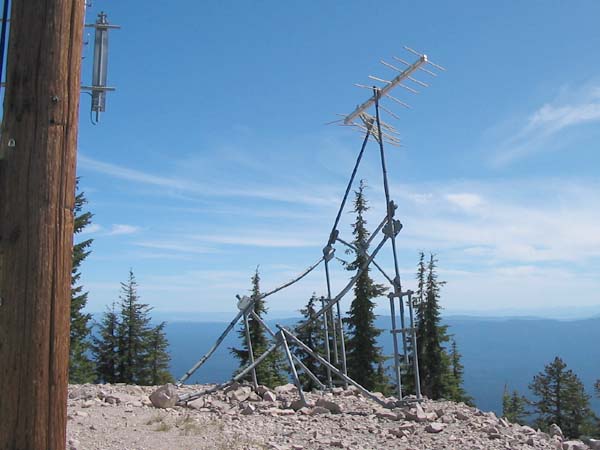
Transmitting Antennas – August 2008
The additional support for the diagonal braces may have helped some, but not enough. The bending of even short sections of pipe demonstrates the heavy loads of melting snow that have pressed down on the structure.
Castle Crags State Park appears in the distance.
Transmitting Antennas – Another View
Receiving Antenna
The antenna was installed 140 feet north of the transmitting antennas. It picked up the signal from Park Mountain. The original tower and antenna have now been removed.
Documents from the FCC Database
(http://www.fcc.gov/fcc-bin/fmq?list=0&facid=62999)
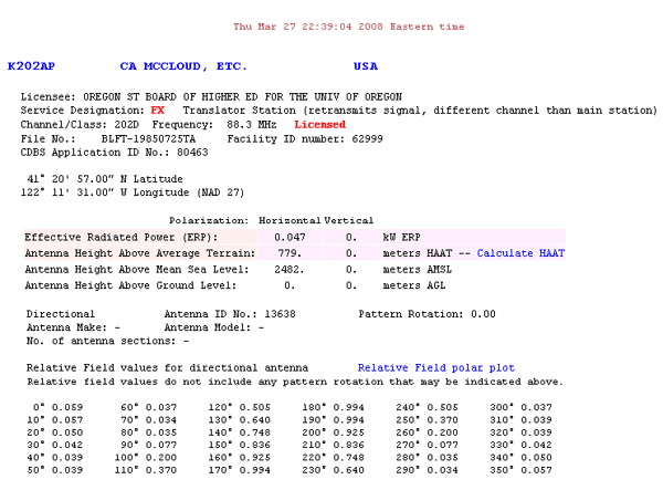
FCC Authorization 2008
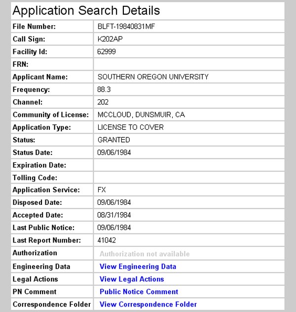
Initial License Grant 1984
Topographic Map
McCloud Quadrangle, U. S. Geological Survey
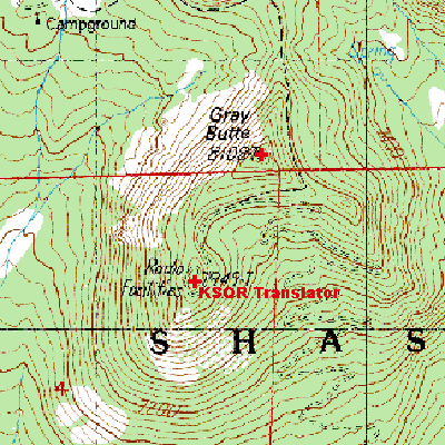
CONTOUR INTERVAL 40 FEET
Geographic Coordinates from the GPS: 41° 20' 43"N, 122° 11' 41"W (NAD27)
Antenna Height Above Mean Sea Level: 2,430 meters (7,974 feet)
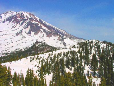
Two Summits
At 8,108 feet, Grey Butte is not a small mountain. Seen at the right side of the picture, its summit is dwarfed by the 14,179-foot Mount Shasta. (This elevation for Mount Shasta is based on the National Geodetic Survey, 2008.)
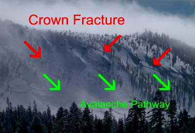
Slab Avalanche
This image appeared on the USDA Forest Service website for the Mt. Shasta Avalanche Center (http://www.shastaavalanche.org) in March 2008. It accompanied the announcement of a 2000-foot slab avalanche that had occurred on February 24, 2008.
This picture was likely taken from the vicinity of Panther Meadow. It shows the northwest side of the ridge between the Grey Butte summit (at the left, beyond the edge of the picture) and the translator site (at the right-hand end of the ridge). The avalanche was close to the radio site, but slightly to the north and below. It had no effect on the facility.
The Two Summits photo (above) was taken 11 weeks after the avalanche. The ridgeline between the summit and the radio site was not affected. The avalanche started just beyond the edge where the terrain became very steep.
One winter, I cross-country skied to Grey Butte in order to repair the translator. From Panther Meadow, I took a course more or less directly to the summit. I used climbing skins to make the steep ascent. From the picture, it is clear that I passed through the corner of the area that avalanched. This is unsettling because I had thought I was exercising caution. Having checked snow and weather conditions that day, I had been concerned about danger from higher on Mt. Shasta, but not that particular area because it was heavily wooded. (John Patton 2008).