Scott Mountain
Serving Sutherlin and Glide at 89.3 MHz
Location: 13 miles east of Sutherlin, five miles northeast of Glide, and 61 miles northwest of its namesake in Crater Lake National Park (geographic coordinates and map).
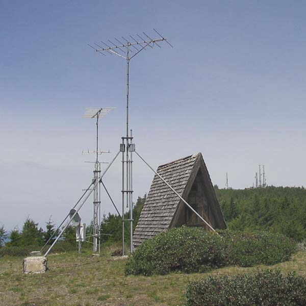
Picture was taken in June 2008.
Translator Site
The A-frame building housed the translator and other communications radios. This site is three-quarters of a mile southeast of the summit (map). Just to the right of the building, the principal radio site is apparent in the distance.
The mast in the foreground holds the single receiving antenna. It picked up a signal from the translator on Mt. Nebo in Roseburg.
The mast in the background holds two transmitting antennas. The upper antenna, a Scala HDCA-10, provided a signal for Sutherlin. The lower antenna, a Scala HDCA-5, provided a signal for Glide. Other items below these antennas are not related to the translator.
We set the vertical tower sections in holes that we had dug to a depth of two feet. Then, we filled the holes with concrete to a level just even with the surface. The rock was hard and very difficult to penetrate with hand tools. For the diagonal braces, we easily decided to leave the concrete blocks resting on top of the ground. We set plywood forms around the end of each diagonal, added rebar for strength, and mixed the concrete by hand.
Documents from the FCC Database
(http://www.fcc.gov/fcc-bin/fmq?list=0&facid=63002)
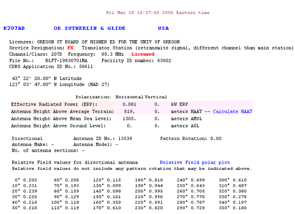
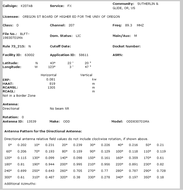
FCC Authorization in 2008
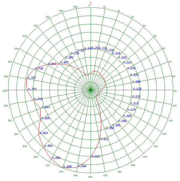
Relative Field Polar Plot for 2008
License Grant in 1983 for the upgrade to an XL10-FM2 Translator
Engineering Data for the License Grant in 1983
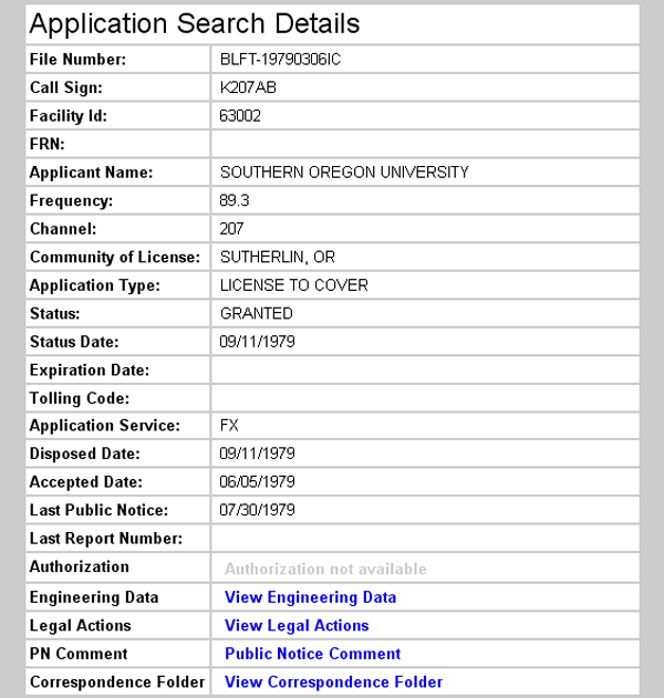
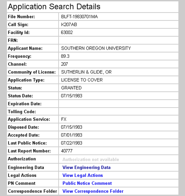
Initial License Grant in 1979 for use of a Tepco J-317 Translator
The FCC Record
The FCC Database records the initial license grant of 1979, but does not include the engineering data. The license grant of 1983 covers the replacement of the Tepco J-317 translator by a TTC XL10-FM2. This record does include the engineering data, but the geographic coordinates and elevation are in error. The correct information is presented with the map, below.
The Relative Field Polar Plot is not included with the FCC's data for 1983, but the relative field values are the same as given for 2008. Therefore, the Relative Field Polar Plot for 2008 accurately represents the data recorded for 1983. This data is in error because it depicts the HDCA-10 yagi providing the signal for Glide, and the HDCA-5 yagi providing the signal for Sutherlin. In reality, the reverse was true. The residents of Glide were closer and spread over a wider arc, and therefore were served with the five-element antenna. The residents of Sutherlin were more distant, so the ten-element antenna provided a stronger and more focused signal for that area. Check the picture, above.
Topographic Map
Glide and Hinkle Creek Quadrangles, U. S. Geological Survey
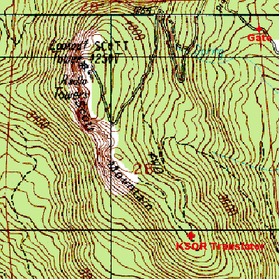
CONTOUR INTERVAL 40 FEET
Geographic Coordinates from the GPS: 42° 21' 49"N, 123° 3' 22"W (NAD27)
Antenna Height Above Mean Sea Level: 1,238 meters (4,062 feet)
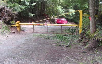
The Gate