Walker Mountain
Serving La Pine, Gilchrist, Crescent, Chemult, Beaver Marsh and Diamond Junction at
89.1 MHz
Location: 14 miles north of Chemult, 13 miles south of Gilchrist and three miles southeast of the intersection of Oregon Route 58 with U.S. Route 97 (geographic coordinates and map).
Pictures with snow were taken in June 2008, the others in late September.
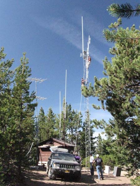
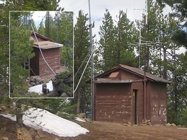
A Multi-Use Facility
A crew from the Walker Range Fire Patrol Association is installing a new communications antenna. Several communications radios as well as a TV translator and KSOR's FM translator use this building.
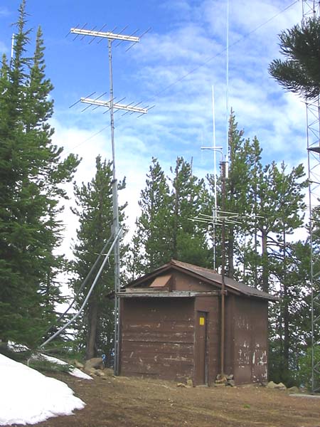
Transmitting Antennas
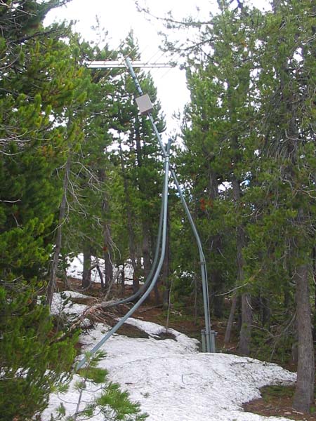
Yes, the tower is leaning! Heavy snow loads have bent the diagonal braces and thereby have pulled the main tower away from vertical.
I was at Walker probably 13 years ago (the top antenna's coax was bad and needed replacing), and there was none of that damage, so it has happened since then. . . (Todd Cory, email, June 9, 2008)
The upper CL-FM served the communities of Chemult, Beaver Marsh and Diamond Junction to the south and provided a signal for the Agency Hill translator. The lower CL-FM sent a signal north to La Pine, Gilchrist and Crescent.
Receiving Antenna
Heavy snow has bent the diagonal braces. Tower damage appears similar to that at Grey Butte, but the antenna has not been harmed.
The antenna was installed 125 feet south of the transmitting antennas. The signal coming from Mt. Baldy passed directly over Scott Mountain on the east side of Crater Lake National Park. The small box beneath the antenna held the preamplifier. Steel conduit snaked through the rocks back to the translator building in order to protect the coaxial cable.
Winter Access
The translator building includes a vestibule with a conventional door and a roof hatch. In deep snow, one can enter through the roof. Inside, a ladder is permanently affixed to the wall for descent to floor level.
To activate the translator, we traveled to this site by snowmobile from Highway 97. The snow was about six feet deep. We used a shovel to gain entry through the side door.
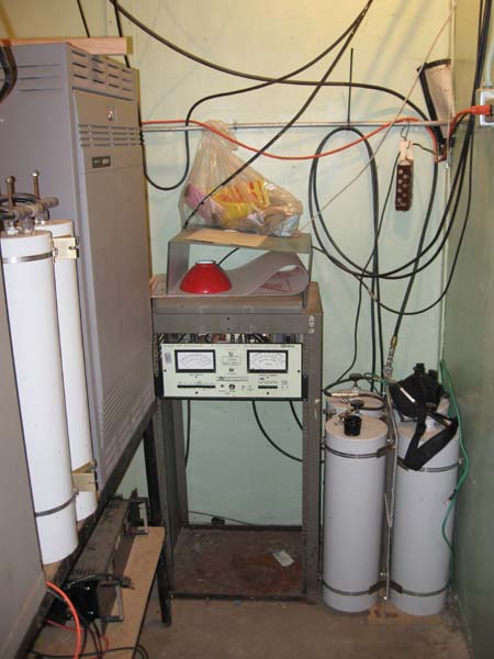
Wires, Wires Everywhere
Inside the building, the KSOR translator resides in a small equipment rack that sits against the far wall. The long cylindrical objects are cavity resonators used by the two-way communications radios. They serve as narrowband filters that allow the simultaneous operation of a transmitter and a receiver using a single antenna.
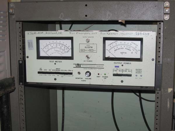
The XL10-FM2 Translator
With two large panel meters and multiple switches, it was possible to evaluate the translator's operation without disassembly or the use of external test equipment. One could even plug in headphones and listen to the signal being rebroadcast.
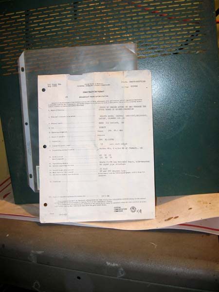
Construction Permit
This copy of the FCC authorization granted on October 5, 1983 was left with the translator when it was first turned on. The folds in the paper are the result of it being carried in the author's pocket when he traveled to the site by snowmobile.
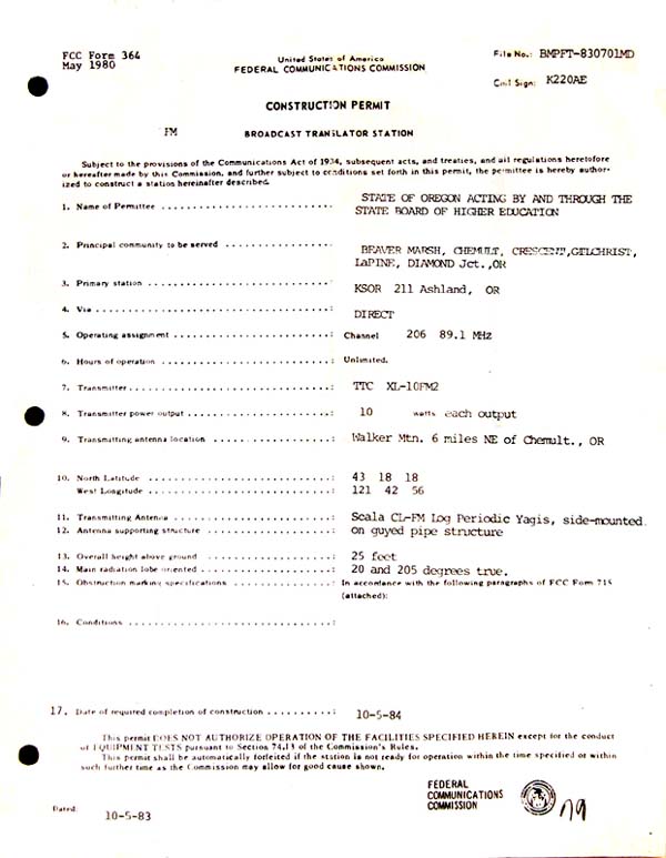
Image of the Construction Permit after Digital Touchup
The History of Waiting
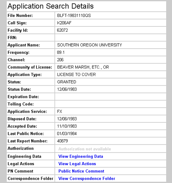
The first Construction Permit (CP) for Walker Mountain was granted on January 29, 1980. Next, a CP was granted on June 2, 1982 to replace the original permit that had expired. Then, an extension of the second CP was granted on December 29, 1982. Finally, there was the "Major Modification to a Construction Permit," seen here, that was granted on October 5, 1983. (From the FCC Database, the Application Search Results for the Walker Mountain translator, November 14, 2008: http://fjallfoss.fcc.gov/cgi-bin/ws.exe/prod/cdbs/pubacc/prod/app_list.pl?Facility_id=62072.)
The delay was a result of our resolve to use the XL-FM translator coupled with the necessity of waiting for its certification by the FCC. The first Construction Permit was granted for the use of a J-317 translator, but until the FCC officially approved the XL-FM, the station had no choice other than to apply for time extensions of the original CP. As soon as the XL-FM was certified, we applied for a "Major Modification" to the CP.
Looking ahead to the snow that would arrive in the fall of 1983, we began installation at the end of summer. We completed the towers and antennas as authorized by the existing Construction Permit, but stopped short of activating a J-317. We were already in possession of the XL-FM translator, but there was no option but to wait for official word from the FCC. The new CP was granted on October 5th, and it arrived in the mail several days later. Friends of KSOR had arranged the use of a snowmobile, so we lost no time in returning to the site and putting the translator on the air.
Documents from the FCC Database
(http://www.fcc.gov/fcc-bin/fmq?list=0&facid=62072)
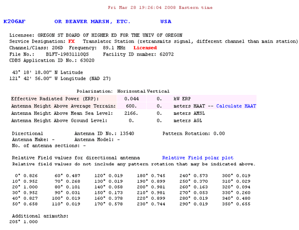
FCC Authorization 2008
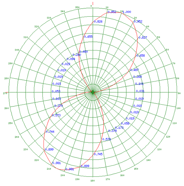
Relative Field Polar Plot 2008
Initial License Grant 1983
Topographic Map
Walker Mountain Quadrangle, U. S. Geological Survey
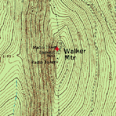
CONTOUR INTERVAL 20 FEET
Geographic Coordinates from the GPS: 43° 18' 22"N, 121° 42' 57"W (NAD27)
Antenna Height Above Mean Sea Level: 2,166 meters (7,106 feet)
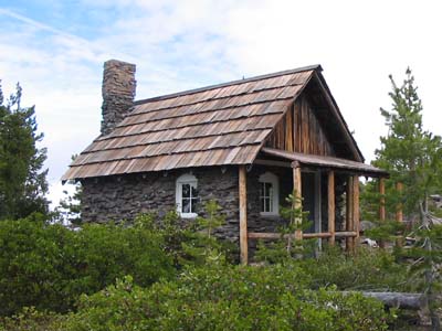
Historic Cabin at the Walker Mt. Lookout and Electronic Site
Forest Service records indicate that the stone cabin was constructed between 1914 and 1917. It is completely unique among administrative site complexes in the Pacific Northwest Region and, likely, the rest of the country. . . . (Leslie Hickerson, District Archaeologist, Deschutes National Forest, "Walker Mountain PIT Project . . . 1998," from the Passport in Time website: http://www.passportintime.com, August 28, 2008.)